Overview
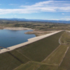
The Ben Smith Dam is located on the Assabet River in Maynard, Massachusetts. The Assabet River is located approximately twenty miles west of Boston. Nine dams are located along the thirty-two mile northeastern span of the river – the largest being the Ben Smith Dam. It was built in the early 1900’s by Armory Maynard to store the Assabet River waters for the town mill. The dam is approximately 51m long (170 ft.) and 3m high (9.5 ft.), impounding a reservoir of approximately 18.75-acres. A 485m (1600 ft.) power canal and culvert leads to a gatehouse with manually controlled gates, then downstream of the gatehouse to an 18.3-acre upper and lower millpond system. A view of the dam is shown below.
When the project was operated for power production, the water was diverted from the impoundment created by the dam into the power canal, through the gatehouse and ponds, into an intake/trashrack structure and through a 15m (49 ft.) long, 2m (7 ft.) diameter steel penstock to a powerhouse.
After leaving the powerhouse, the water passed through twin 90m (300 ft.) long tailrace tunnels to rejoin the Assabet River about 1635m (5400 ft.) downstream of the Ben Smith Dam. The project’s total installed capacity was 125 kilowatts. In the 1980’s Digital Equipment Corporate was issued an exemption to produce hydroelectric power for the 45-acre commercial office complex (originally called Maynard Mill, now called Clock Tower Place). The office complex was eventually sold and generation ended in the early 1990’s. The current owners are pursuing an exemption to resume hydroelectric generation at the site. One of the key requirements however is maintenance of a minimum 39 cubic feet per second (cfs) water flow down the Assabet River to maintain downstream aquatic habitat.
What We Did
The owner was required to demonstrate compliance with the minimum flow requirement of the Assabet river. Monitoring of the river flow and canal flow using Sontek Argonaut Doppler flowmeters was specified to provide this compliance monitoring.
We were tasked with design, fabrication and installation of the 2 monitoring systems to automatically read the Argonauts. We were also tasked with coordinating river surveys to program the Argonauts, installation of staff gages to provide manual stream level measurements, and deployment of a publicly accessible Internet website to provide the monitoring data with hourly data updates. Remote telemetry is provided using cellular IP modems, solar panels are provided for maintaining system battery power at both sites. A view of the river monitoring system installed on the downstream Great Road bridge is shown at right.
Data are collected automatically every hour and imported into the MLDB database. Our MLWeb software is used to present the flow and level data for public viewing using the Internet. A view of the project interface showing the up-to-the-hour data is shown below. The site is hosted using our in-house servers. Take a moment to visit the site:


